
$ 0.00

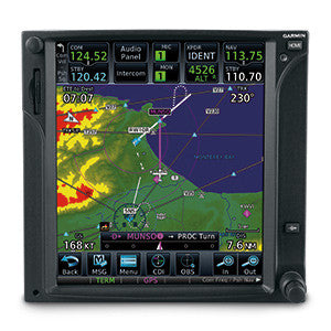
GTN 650 is a fully integrated solution in a small package. It combines GPS, COM and NAV functions with powerful multifunction display capabilities such as high-resolution terrain mapping, graphical flight planning, multiple weather options and traffic display.
GTN 650
Touch & Go
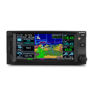
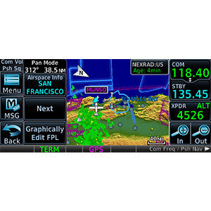
With GTN 650’s touchscreen interface, you’re rarely more than 2 taps away from the system’s primary functions. Enter waypoint data on the 4.9" high-resolution TFT display and swipe your finger across it to pan the map screen. Built-in gripping points on the bezel and lower edge of the display help you stabilize your fingers while using the touchscreen in-flight. Not keen on touchscreen data entry? GTN 650 also has traditional concentric knobs. And, with a GNS 430W/530W, your active flight plan automatically crossfills from the GTN to the GNS. You can also manually crossfill waypoints.
Navigate Easily
Edit your entire route on the map screen and easily enter new waypoints or modify existing ones. The system even lets you load Victor and jet airways. Grab any leg of your flight plan route and move it to accommodate a deviation or ATC amendment to your flight plan with the "rubber band" feature. Enter your most recently visited or nearest airports as waypoints and “Direct To” destinations.
You now have more landing options in IFR conditions. The SBAS/WAAS-certified, 15-channel GPS receiver generates 5 position updates per second, letting you fly GPS-guided LPV glidepath instrument approaches down to as low as 200 feet. The system includes a complete package of VHF navigation capabilities, with a 200-channel VOR/ILS with localizer and glidescope. GTN will preload NAV frequencies for you to manually switch to and can auto select the VHF NAV source for ILS approaches when you load procedures. In addition, precise course deviation and roll steering outputs can be coupled to select autopilots so that IFR flight procedures may be flown automatically. This includes all ARINC 424 leg types, except RF legs. For example, when coupled with a G500/G600 Flight Display, the aircraft can fly fully coupled missed approaches, including heading legs.
Communication Is a Breeze
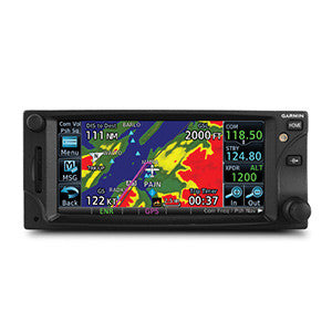
A fully certified, 2,280-channel VHF communications transceiver provides a standard 10 W (or optional 16 W) of power output. The system is pilot-selectable to both 25 kHz and 8.33 kHz channel spacing. Set your standby COM frequency simply by touching the onscreen number pad. Another touch of the screen flip-flops your active and standby frequencies. Access recent and favorite user frequencies easily. For added safety, holding down the volume knob will automatically dial in the emergency frequency.
See More Than Ever Before
Packed full of multifunction display capabilities, GTN 650 brings enhanced situational awareness to your cockpit. High-resolution terrain mapping — including topography features, cities, airports, terminal areas, SUAs and optional Class B TAWS alerting — help you find your way around airspace safely. Smart Airspace™ automatically highlights airspace close to your current altitude and de-emphasizes airspace away from the current altitude. On the ground, built-in Garmin SafeTaxi® airport diagrams show you geo-referenced runways, taxiways, FBOs and hangars available in either the U.S., Europe or Canada.
Add Traffic & Weather
The dual-link GDL® 88 allows GTN 650 to display up to 60 ADS-B traffic targets. TargetTrend™ relative motion technology gives you a faster, more intuitive way to judge the direction and closure rate of intruding targets in relation to your aircraft’s position. And unique SURF technology supports the display of ADS-B-equipped surface targets on Garmin SafeTaxi® airport diagrams — including taxiing aircraft and ground vehicles. GDL 88 can also receive the FAA’s subscription-free FIS-B weather broadcasts that include graphical NEXRAD radar information, as well as NOTAMs, METARs and TAFs. GTN provides GDL 88 with the WAAS position source required for ADS-B, so a WAAS version of GDL 88 is not required. Add a Garmin Traffic System to compliment GDL 88 for the best possible traffic coverage from now until 2020.
Add a GDL® 69/69A datalink receiver for XM WX Satellite Weather and SiriusXM Satellite Radio (subscriptions required). An optional GSR 56 provides World Wide Weather data almost anywhere on the globe, as well as the ability to make and receive phone calls and send and receive texts messages while in the air.
Use GTN 650 with a Garmin Traffic System to help pinpoint other aircraft in your vicinity. And because it can control a GTX™ 33 remote transponder, a GTN 650 installation saves you valuable panel space.
$ 0.00
Experience the G600Bringing true “glass cockpit” capabilities to your aircraft, G600 is a retrofit breakthrough....
$ 0.00
Packed full of powerful avionics, GTN 750 is a fully integrated GPS/NAV/COM/MFD solution. The...